
25 June 2016
The light is a waning moon to the East, casting a beautiful glow on the water with scattered lightening to the North as we cruise out of Brunswick. It’s 12:45 AM. The building cumulonimbus clouds are visible with each flash. They are not threatening. Since we are in cell phone range, (and we hope to maintain that as long as possible) we can still call up the weather radar and see we are safe for the next several hours.
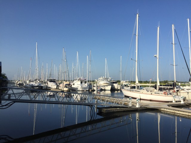
We had spent the last 36 hours making some repairs and preparations for a brief voyage to get our sailboat Lost Loon to St Mary’s Boat Services for the off-season. And so we are underway. We navigate the zig-zag route toward the inlet, watching for unlit channel markers with precision. The docking hardware is stowed and we begin to ready the safety equipment. We are anticipating an uneventful ride, but will always be prepared. As this is Kelsey’s first overnight passage, we quickly run through some basic safety guidelines (one sentence…you wear a life jacket on deck at all times). She will keep watch with one of us, or sleep (if possible).

The heavy air lightens as we reach the ocean and there is relief from the heat of the city we have left behind. Once we are at St Simon’s sound we travel out another 5 or so miles before we begin our coastal voyage South. The seas are easy at 1-3 feet and the breeze is light. As our eyes adjust to the night surroundings, we approach the final marker and begin to reckon our position with lights ashore. The travel is slow at 6 knots. We need to maintain this average speed to arrive at the St. Mary’s inlet at dawn and not before. However well marked, it is usually unadvisable to make an entrance you haven’t experienced before in the dark.

Mike and I decide that he would take the first watch as I attempt to get comfortable on the cockpit bench for a nap. We are motoring and not sailing so there is no heeling except when we take on a wave of more considerable height and the boat rocks a bit more to one side, so sleep is marginal, but adequate knowing we are finally underway. As my shift begins, it is 0300 am and we have gone beyond the limits of cell service and can no longer obtain cellular radar so I watch the sky for any signs of storms approaching and continue to identify landmarks along the coast. The sky to the South shows signs of electrical activity and continues to move off in that same direction (thankfully). St. Mary’s inlet shows up quickly, but at our speed it looms in the distance. The next few hours pass quickly and as the first signs of morning show in the Northeast we are on schedule for a 7 am arrival at the inlet.
We appreciate full daylight at 0715 and watch the South passing storms resolving. We begin to make our turn West toward the Georgia coast.

Much to our consternation we also observe a darkening in the sky to the Northwest (the direction from which all of the storms have been approaching in the last 24 hours). The radar confirms this. It shows a very large and deep cell coming toward us.


The first wave of light rain and wind hits just as we slip out of the ocean into the inlet. It was just before this that nature provides Kelsey with a semi-promised dolphin sighting.

(Recall that was the one incentive I had mentioned to entice her to make the trip that night). Mike takes the helm from Kelsey. We close up the hatches and go below.
As the thunder and lightening arrive we are making our approach to the intracoastal creek that leads us up to the marina. What is funny is that this creek winds some 2 miles to the marina, but you can actually see it off to starboard about ½ mile. These next 2 miles are supposedly fraught with shallow waters and shoaling /sandbars that MUST be avoided, lest we want to make our first call to Boat US for a tow. Mike determines he has to stay in a confined lagoon where the water is nearly 30 ft deep until the storm passes.
The next harrowing 30 -45 minutes seem like an eternity.(not unlike an episode from The Twilight Zone). He maintains the helm and the boats position through incredibly close lightening strikes and near 30 knot winds. He is doing tight 20 yard circles to maintain position.

At one point, he can only see as far as 15 ft from the boat due to amazingly heavy rainfall. He suddenly sees a blip on the radar, like an approaching vessel. It becomes clear that this is no small boat and a 30-some-foot cruiser that blasts right by amidst the weather chaos. We wonder if he even knew we were there? By this time, with the continuous electrical activity, Kelsey and I have stowed all the electronics (cellphones, ipads, computers, radios) in the stove to act as protection from lightening strike. (I could see the headlines: The electronics survive! 3 souls are lost to lightening strike in Georgia). Every 5 minutes I take the phone out of the oven to check the storm cell position and find that for almost a solid 20 minutes this thing is building right over us! I suppose that as the storm came closer to the warm ocean waters it took on a new life. I am also watching the wind speed indicator down below in amazement and see gusts over 30 knots.

Right next this is a chartplotter (the one that doesn’t want to be the slave) and I can see Mike’s nice tight circles forming in the basin. (No I didn’t get the phone out for that pic). We wait, and as slowly as this squall approached it finally left us. Mike was drenched. We studied the weather radar and to our disbelief began to appraise another storm approaching. This was hitting Brunswick at the current time, and unfortunately we couldn’t figure out how fast it was approaching. It was 10:00 presently and we had at least a 45-minute slow run up the winding creek to the marina to our final dockage. We contacted the owner and he was ready for us whenever we arrived. We needed to go.
I begin readying the bowlines and fenders as well as releasing the lock on the anchor and checking the windlass (If we had another storm out here, we would end up on the shore without a doubt, unless we somehow anchored ourselves in the middle until it passed…we would be ready like a boy scout).With Kelsey watching port and myself to starboard we began the final leg of this short journey to dry storage.

The chart plotter maps are good (no …they are really indispensible), but one must depend on visual reckoning under these situations. That would prove to be impossible however, for after the storm this shallow body of moving water was now deeply brown, there was no indication as to depth. So, my job became watching for floating obstructions (logs).
Maneuvering the boat in a bit of a current, trying to avoid sand and shallow depths, was challenging. After our first or second negotiated turn, we felt a very slow and quite identifiable surge to a halt. The keel hit bottom. It was very temporary as with Mike’s quick action at the wheel and reversal of the prop we were off. (Uncharted shoaling is quickly humbling). We all regain our breath. Around the next bend, we are rewarded by the sighting of a small flock of pink flamingos along the shoreline. (We take that as a good sign). Our final approach to the marina is made and in Lost Loon-style, Kelsey and I make docking the boat (however on a rusty steel barge) “look easy”. I think that Mike’s first words, as we made the final figure eights on the cleats, were “holy s— where’s the bourbon?”

The radar was showing a continued approach of the next thunderstorm. Rocky, the marina owner indicated that he would have his team ready to put us in the slings quickly to pull the sailboat out of the water. This would mean we would have to remove our belongings down a ladder once the boat was secure out of the water.

Mike was instructed to motor into the slings, which did require him to work against a current, but as he made the approach and pulled into the slings, they realized that we would need to come in stern first. With the size of the boat, and specific placement of the slings to avoid the keel, they noticed the forward jib forestay would not fit. I wasn’t on the boat, but I could hear Mike’s thoughts….”this boat doesn’t have good reverse propulsion ….&^%$ # #@#%… and against a current it could be difficult, if not near impossible”. Once back out of the sling, Mike made an initial attempt at holding the wheel over hard in reverse and there was little position change. I could see the frustration in his face, he tried with as much engine power as he could. from where Kelsey and I were it appeared just plain stuck! So, for the next 25 minutes, those marina boys on the mechanical sling wrestled Lost Loon like a wayward calf. With ropes pulling the stern, boat hooks pushing the bow and the strength of a prizefighter, they were able to turn that boat right around and allow Mike to back into the sling stern first.
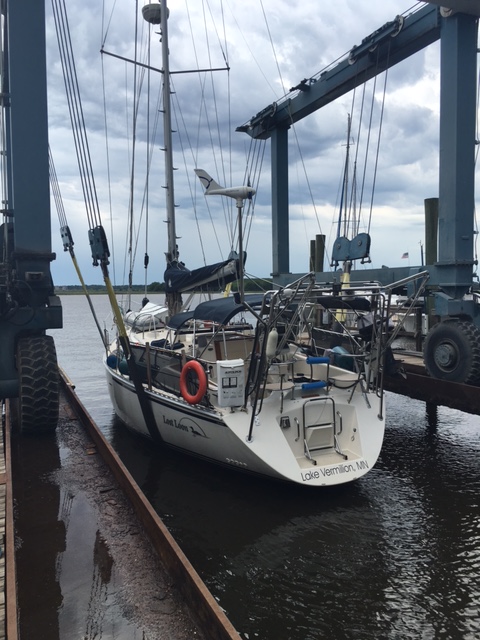
Finally in correct position Lost Loon was lifted out of the brackish water, dripping wet, but no worse for wear, ready for respite. The mechanical sling moved her over the hard concrete as the first sound of thunder approached. (It brought to memory a trip Mike and I attempted to make from Grand Portage MN to Isle Royale, 2 yrs previous ,when we had to return to shore to spend almost 3 hours trying to de-rig our Precision 23 in the middle of a gale….ok terrible lightening rainstorm.)
With a ladder in place, we were able to again access to the boat and I can’t recall if it were Mike or Kelsey that opened the first beer. We began the process of unloading our gear, having lunch, and re-organizing (have I mentioned that is a never ending process? ) The final tasks were underway to close the boat in light showers, a bit of thunder, no wind or lightening. We closed hatches and placed the canvas cover sadly and systematically….for the 3rd time this year. We had somehow become attached to this new/temporary home. Moving her from port to port as we continued to dream of a time when we can spend more than a week or so traveling.

We needed to get back to Brunswick to retrieve Kelsey’s car and the marina offered a car for use. The only problem was that the marina owners had loaned it to someone else. We would wait…..and took our time getting everything in place on the boat for the summer storage ….and we waited…..
We completed all our work, had another “cool one ” and were still waiting…it was just as we made a call to a local cab that they returned with the loaner. We made a 60-minute round-trip to Brunswick and back before we were off for Cape Canaveral. The next event on the agenda was to deliver our Platismo 6-person life raft for re-certification the following morning.
We arrived at that night’s hotel tired and ready for rest! We had found a reasonable rate near Cape Canaveral, so we would be close and on time for our appointment to discuss and deploy our life raft the next morning. Every 5-7 years if unused a life raft should be taken out of its valise and checked for small tears or deterioration, as well as inspection of the CO2 canister to inflate said raft.
We had previously discussed with Gator, the owner of Lifeline Marine Safety Services, that we would review what we had on the raft and what we would need as well in emergency. He would also inflate it so we could appreciate the process, with hope that we would never have to do that again. We were greeted and escorted to a warehouse type room accompanied by our life raft. After a great in depth discussion of safety, when to deploy and board the raft, as well as options for safety equipment to stow, we eventually did inflate the rescue vehicle. As this had never been re-certified or deployed before, we found it was in excellent condition.

It was a great experience, however foreboding, to think of our precious Lost Loon sinking and having to abandon her for the safety of our lives.
We finalized options for our survival tent and were quickly on our way again, heading much further South, but now on vacation for SCUBA diving, snorkeling, fishing and relaxing!


Twenty years from now you will be more disappointed by the thing you didn’t do than by the ones you did do.
So throw off the bowlines.
Sail away from the safe harbor.
Catch the trade winds in your sails.
Explore. Dream. Discover. Mark Twain